| Chesapeake and Ohio Canal | |
|---|---|

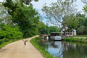
The Chesapeake and Ohio Canal at Lock 20
| |
| Specifications | |
| Length | 184.5 miles (296.9 km) |
| Maximum boat length | 90 ft 0 in (27.43 m) |
| Maximum boat beam | 14 ft 6 in (4.42 m) |
| Locks | 74 (Boats must pass guard locks 4 & 5 for each trip.) |
| Status | National Park |
| History | |
| Original owner | Chesapeake and Ohio Canal Company |
| Principal engineer | Benjamin Wright |
| Other engineer(s) | Charles B. Fisk, William Rich Hutton |
| Date of act | 1825 |
| Construction began | 1828 |
| Date of first use | 1830 |
| Date completed | 1850 |
| Date closed | 1924 |
| Geography | |
| Start point | Georgetown, Washington DC (originally Little Falls, MD) (Canal extended down to Georgetown in 1830) |
| End point | Cumberland, MD (originally Sections to Pittsburgh, PA never built) |
| Connects to | Alexandria Canal (Virginia), Goose Creek & Little River Navigation |
Tuesday, September 15, 2015
My maternal grandfather told me that Cumberland, MD had the map of the continental USA in its lights............house lights/street lights....................we went to a hill overlooking said city........but i couldn't tell...........when i was a kid...............we were visiting my mother's younger brother..........who had moved there..................he had the family business...............and relocated it there........the Doll Reader.........
Subscribe to:
Post Comments (Atom)
No comments:
Post a Comment