The chiseled-out fifth line reportedly once incorrectly stated: "BEING THE CENTER POINT OF THE".[5][6]
Plan of Washington, D.C.[edit]
According to a notation on Pierre (Peter) Charles L'Enfant's 1791 "Plan of the city intended for the permanent seat of the government of the United States...", Andrew Ellicottmeasured a prime meridian (longitude 0°0') through the future site of the U.S. Capitol.[7][8] (Shortly after L'Enfant prepared this plan, its subject received the name "City of Washington".) Thomas Jefferson, who at the time was serving as the United States Secretary of State, supervised Ellicott's and L'Enfant's activities during the initial planning of the nation's capital city. Jefferson hoped that the United States would become scientifically as well as politically independent from Europe. He therefore desired that the new nation's capital city should contain a new "first meridian".
A prominent geometric feature of L'Enfant's plan was a large right triangle whose hypotenuse was a wide avenue (now part of Pennsylvania Avenue, NW) connecting the "President's house" (now the White House) and the "Congress house" (now the U.S. Capitol building).[9] To complete the triangle, a line projecting due south from the center of the President's house intersected at a right angle a line projecting due west from the center of the Congress house.[9] A 400 feet (122 m)-wide garden-lined "grand avenue" would travel for about 1 mile (1.6 km) along the east-west line.[9] L'Enfant chose the west end of the "grand avenue" (at the triangle's southwest corner) to be the location of a future equestrian statue of George Washington for which the Continental Congress had voted in 1783.[9] (Although the planned "grand avenue" became the portion of the National Mall that is now between the Capitol's grounds and the Washington Monument, neither the avenue nor Washington's equestrian statue were ever constructed (see:National Mall)).
Planning for Washington Monument[edit]
In 1804, Jefferson requested a survey of a meridian through the President's house while living in the house when serving as the President of the United States. It is not known why Jefferson requested a survey of a new meridian after he had previously directed a survey of a different one while serving as Secretary of State eleven years earlier.
In accordance with Jefferson's request, Isaac Briggs used a transit and equal altitude instrument (see Theodolite)[10] to survey a new meridian line extending south from the center of the President's House that intersected a line extending due west from the planned center of the Capitol building.[11][12] On October 15, 1804, Nicholas King, Surveyor of the City of Washington, erected at the intersection "a small pier, covered by a flat free stone, on which the lines are drawn." [12] This established the Washington Meridian (sometimes termed the "16th Street Meridian"), now at a longitude 77°2'11.56" (NAD 83) west of the Royal Observatory, Greenwich.[2] The pier and stone were located at the point that L'Enfant's plan had identified as being the future site of George Washington's equestrian statue. A pier is a massive pillar capable of supporting a great weight.[13] Most of the length of a surveying pier is buried vertically in the ground for stability. Free stone is fine grained stone soft enough to carve with a chisel, yet has no tendency to split in any preferential direction.
Another stone, the Capitol Stone, was erected where the north-south line from the President's house intersected a line extending west from the south end of the Capitol, and a third stone, the Meridian Stone, was erected on the north-south meridian two miles north on Peters Hill, now Meridian Hill. Neither of the two latter stones survives. Due to errors either when the Jefferson Pier was initially surveyed or when it was replaced, its center is now 2.23 ft (0.680 m) south of the Capitol's centerline.[14]
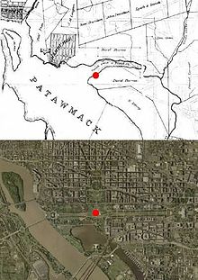
The 1804 stone marker replaced one of two wooden posts driven into the ground in 1793 at its site.[15] The marker was originally located on the south bank of Tiber Creek,[12] near the creek's confluence with thePotomac River. The area of the present National Mall west of the marker was under water until an engineering project that Peter Conover Hains directed from 1882 to 1891 created West Potomac Park.[16] East of the marker, Tiber Creek was transformed into the Washington City Canal.

No comments:
Post a Comment