Recon from Pres. Jefferson...........................spies..........on how to steal the west from the Natives.......
eaching With Documents:
eaching With Documents:
The Lewis and Clark Expedition
Background
In 1803 President Thomas Jefferson guided a splendid piece of foreign diplomacy through the U.S. Senate: the purchase of Louisiana territory from France. After the Louisiana Purchase Treaty was made, Jefferson initiated an exploration of the newly purchased land and the territory beyond the "great rock mountains" in the West.
Jefferson chose his personal secretary, Meriwether Lewis, an intelligent and literate man who also possessed skills as a frontiersman. Lewis in turn solicited the help of William Clark, whose abilities as draftsman and frontiersman were even stronger. Lewis so respected Clark that he made him a co-commanding captain of the Expedition, even though Clark was never recognized as such by the government. Together they collected a diverse military Corps of Discovery that would be able to undertake a two-year journey to the great ocean.
Jefferson hoped that Lewis and Clark would find a water route linking the Columbia and Missouri rivers. This water link would connect the Pacific Ocean with the Mississippi River system, thus giving the new western land access to port markets out of the Gulf of Mexico and to eastern cities along the Ohio River and its minor tributaries. At the time, American and European explorers had only penetrated what would become each end of the Lewis and Clark Trail up the Missouri several miles to the trapper headquarters at Fort Mandan and up the Columbia just a bit over a hundred miles to a point a little beyond present-day Portland, Oregon.
The Lewis and Clark Expedition paddled its way down the Ohio as it prepared the Expedition to be launched officially from Camp Wood, just outside St. Louis, in the summer of 1804. That summer and fall the company of explorers paddled and pulled themselves upstream, northwest on the Missouri River to Fort Mandan, a trading post, where Corps of Discovery set up camp, wintered, and prepared for the journey to the Pacific.
When the spring of 1805 brought high water and favorable weather, the Lewis and Clark Expedition set out on the next leg of its journey. They traveled up the Missouri to present-day Three Forks, Montana, wisely choosing to follow the western-most tributary, the Jefferson River. This route delivered the explorers to the doorstep of the Shoshone Indians, who were skilled at traversing the great rock mountains with horses. Once over the Bitterroot Mountains, the Corps of Discovery shaped canoe-like vessels that transported them swiftly downriver to the mouth of the Columbia, where they wintered (1805-1806) at Fort Clatsop, on the present-day Oregon side of the river.
With journals in hand, Lewis, Clark, and the other members of the Expedition returned to St. Louis by September 1806 to report their findings to Jefferson. Along the way, they continued to trade what few goods they still had with the Indians and set up diplomatic relations with the Indians. Additionally, they recorded their contact with Indians and described (and at times drew) the shape of the landscape and the creatures of this western world, new to the white man. In doing so, they fulfilled many of Jefferson's wishes for the Expedition. Along the way, William Clark drew a series of maps that were remarkably detailed, noting and naming rivers and creeks, significant points in the landscape, the shape of river shore, and spots where the Corps spent each night or camped or portaged for longer periods of time. Later explorers used these maps to further probe the western portion of the continent.
The Expedition of the Corps of Discovery shaped a crude route to the waters of the Pacific and marked an initial pathway for the new nation to spread westward from ocean to ocean, fulfilling what would become to many Americans an obvious destiny.
Over the next two centuries the new Americans and many immigrants would wash across the central and western portions of what would eventually become the contiguous 48 United States. This wave of development would significantly transform virgin forests and grasslands into a landscape of cities, farms, and harvested forests, displacing fauna such as the buffalo and squeezing the Indians who survived onto reservations.
The Documents
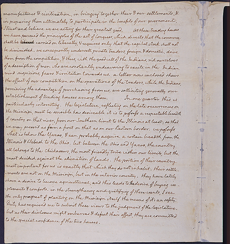
- President Thomas Jefferson's confidential message to Congress concerning relations with the Indians. Pages: 1 | 2 | 3 | 4
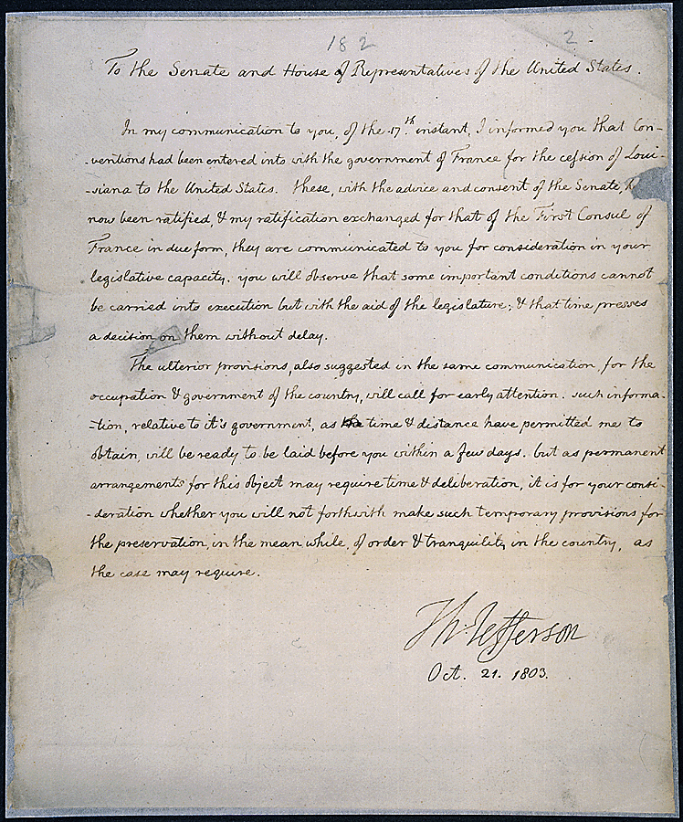
National Archives Identifier 306698 - Message of President Thomas Jefferson laying before the Senate the conventions with France for the cession of the province of Louisiana to the United States
National Archives Identifier: 306460 - Message of President Thomas Jefferson concerning the cession of the province of Louisiana
National Archives Identifier 306461 - French Exchange copy of the Louisiana Purchase Treaty--Convention for Payment of Sums Due by France to U. S. Page 1, Cover, Transcription
National Archives Identifier 299807 - Letter to James Madison, secretary of state, announcing that Louisiana was purchased from France
National Archives Identifier 306704 - Receipt for wine and kegs purchased by Meriwether Lewis
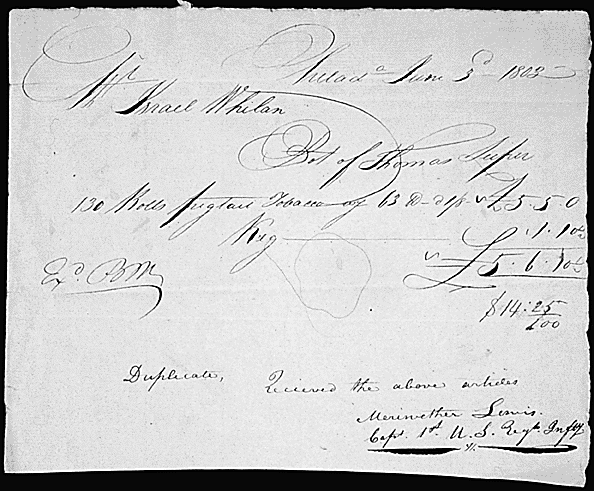
National Archives Identifier 300351 - Receipt for 131 rolls of pigtail tobacco purchased by Meriwether Lewis
National Archives Identifier 300352 - List of Indian presents purchased by Meriwether Lewis
National Archives Identifier 300353 - President Thomas Jefferson's message to Congress communicating the discoveries of the explorers Lewis and Clark. Pages: 1 | 2 | 3
National Archives Identifier 306702 - Photograph: Overlooking the Columbia River at Corbett, near the Cascade Locks on the Lewis and Clark Trail, 1973
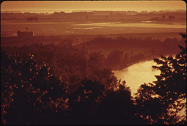
National Archives Identifier 548140 - Photograph: Early morning view of the Missouri River near Atchison, Kansas, 1974 . The scene was described by Lewis and Clark as having much tall grass and abundant game.
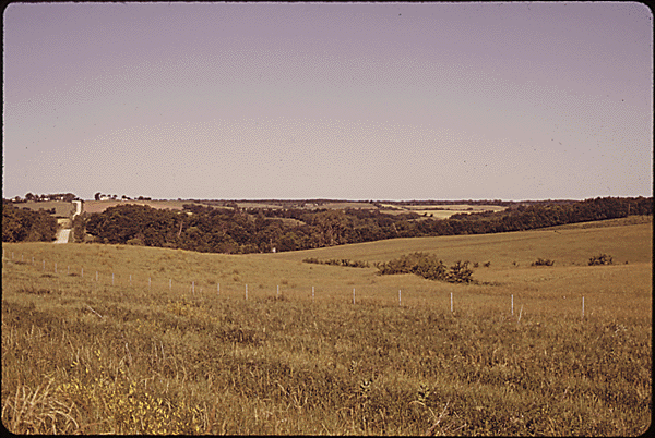
National Archives Identifier 557091 - Photograph: Rolling hills in the outskirts of Atchison, Kansas, 1974 . The tall grass prairie was described by Lewis and Clark and painted by George Catlin between 1830 and 1850.
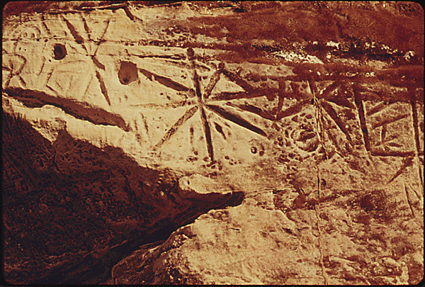
National Archives Identifier 557087 - Photograph: Close up of Indian petroglyphs mentioned in the journal of Lewis and Clark located on a limestone cliff at the mouth of the Nemaha River near Troy, Kansas, 1974.
National Archives Identifier 557117
Article Citation
This article was written by Douglas Perry, a teacher at Gig Harbor High School, in Gig Harbor, WA.
Teachers >


Comments
Post a Comment